
Our Trails
Stroll, walk, jog, run, pedal, roll, or skate your way to healthy exercise on any of the area’s many recreation paths. Maps of the paths in Sterling are available at Duis Recreation and Westwood Fitness & Sports Center.
Download the Path and Trail Map of Sterling, Illinois. ![]()
Major Paths
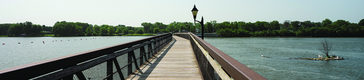
Martin’s Landing & Sinnissippi Dam Walkway
.25-mile path
10th Avenue & 2nd Street
These are two of the area’s finest recreational gems. Martin’s Landing is a park that welcomes visitors to the north side of the Rock River into Sterling with a path leading to the Dillon Home Museum. The Sinnissippi Dam Walkway is an approximately .25 mile long pedestrian bridge that links the communities of Sterling and Rock Falls over the Rock River. It also provides the link between the ever expanding trail system in Sterling and the Hennepin Feeder Canal in Rock Falls. The Feeder Canal ties into the main Hennepin Canal and becomes part of the Grand Illinois Trail. The Sterling Park District, along with the Coloma Township Park District, the City of Sterling, the City of Rock Falls and the Illinois Department of Natural Resources combined forces to obtain local, state and federal funds and significant private donations to complete the project. The end result is a park and walkway that can be enjoyed by all ages year round.
Sinnissippi & Hoover Parks (S.M.A.R.T.) to the Dillon Home Museum
2.25-mile path
3807 Woodlawn Road
This section of trail can be accessed at the Hoover Park parking lot off of Woodlawn Road, the east shelter in Sinnissippi Park off the parking lot and underneath the road bridge across from the playground near the Sinnissippi Park entrance. This portion of the Sterling Multi-Activity Recreational Trail (S.M.A.R.T.) consists of 1.25 miles of paved asphalt path with a scenic wooden bridge over Woodlawn Creek linking the two parks. The trail continues .75 mile west along the Sinnissippi Bayou and connects to Redfield Park and city streets until reaching the Dillon Home and Martin’s Landing. Hoover Park has a playground for young children at the trailhead. Sinnissippi Park has two shelters with bathrooms, two playgrounds, a disc golf course, two softball diamonds and ample green space for playing, exploring or just relaxing.
Lynn Boulevard/Westwood Trail
3.7-mile path
Lynn Boulevard/S Road from YMCA Way
The trail parallels Lynn Boulevard on the south side of the road from YMCA Way on the east end to LeFevre Road on the west end. This section is 1.7 miles in length. The trail crosses Lynn Boulevard at LeFevre Road and heads onto the Westwood trail system for approximately 2 miles. Here the trail meanders around the Ballard Shelter, which overlooks a man-made lake. The paved trail then travels along Elkhorn Creek through a wooded area directly behind the Sterling Park District’s main recreational facility, Westwood Fitness & Sports Center. Trail users can directly access Westwood’s parking lot from the trail or they can continue to circle back to the trail head.
Thomas Park Trail
This 0.7 mile trail, which was funded through a Safe Route to School Grant, starts at the corner of 6th Avenue and Lynn Boulevard. The trail continues east through Thomas Park and ends at the corner of East 25th Street and 16th Avenue, which is adjacent to Franklin School.
Hoover Park to Sauk Valley College
This 3.5 mile section of the trail, which begins at the Hoover Park Parking Lot and ends at Sauk Valley College will be constructed in stages with a target completion date of the spring of 2026. Section 1, which is located behind Woodlawn Arts Academy, and Section 2, which included the widening of Woodlawn Road, were completed in 2021. Construction on Section 3, between Woodlawn and River Roads began in the fall of 2022 and was completed in the spring of 2023. Section 4 from River Road to 43rd Ave, will be completed by the spring of 2024 with Section 5 from 43rd Ave. to Mound Hill Road being completed by the spring of 2025 and Section 6 from Mound Hill Road to Sauk Valley College being finished by the spring of 2026.
Trail Etiquette
- Paved trails are for cyclists, skaters, runners & walkers.
- Helmets are encouraged for cyclists and skaters.
- Keep pets on a short leash and under control at all times.
- Clean up after your pets.
- Children should be monitored by parents at all times.
- Trail users should keep to the right side of the trail, except when passing.
- Give an audible waning when preparing to pass. Always pass on the left side leaving at least 2 feet of clearance.
- Pedestrians have the right-of-way on trails. Groups should move into a single-file line to allow for cyclists to pass.
- Move off the trail pavement when stopping.
- Travel at safe and appropriate speeds when cycling and skating.
- Pay attention to trail markings and safety signs.